California bracing for extreme rainfall. Here’s why this atmospheric river will be different
Posted on 11/18/2024

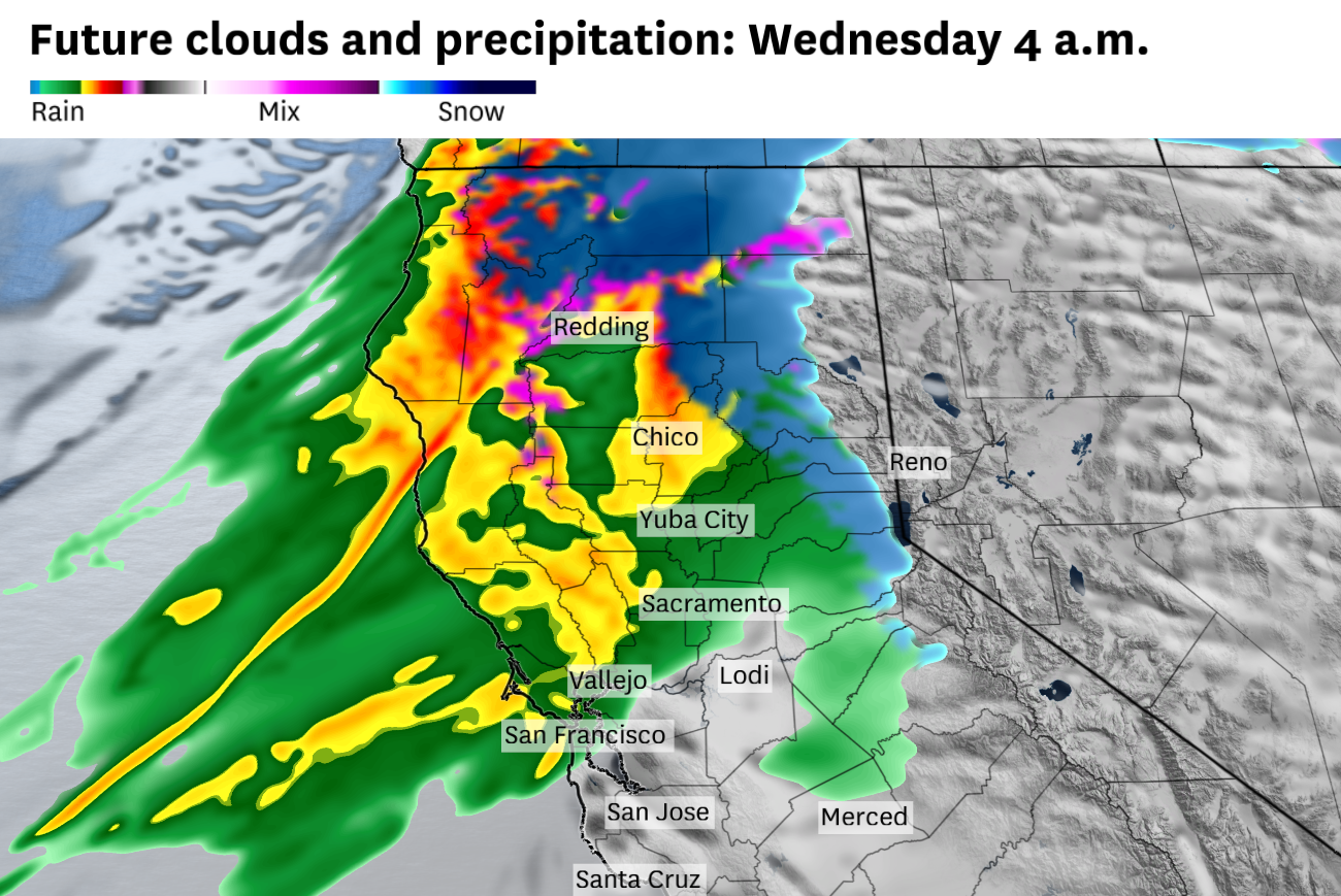
After a relatively tranquil, dry fall in California, this week’s weather forecast could not be more different. Extreme rainfall totals are predicted throughout parts of the Bay Area, North Coast, Sacramento Valley and northern Sierra Nevada due to an extreme atmospheric river, probably the strongest to hit the areas in several years.
Mechanisms for a long-lasting atmospheric river-fueled storm are predicted to be in play in Northern California. As a result, heavy rain is expected from Tuesday night through at least Saturday morning, with possible flooding.
Advertisement
Article continues below this ad
Over the Pacific Ocean, a powerful system will develop Monday into Tuesday. The central atmospheric pressure of the storm is forecast to drop 31 hectopascals — a unit of air pressure — in 24 hours, which would meet the criteria for bombogenesis, or a bomb cyclone.
Although the bomb cyclone will be hundreds of miles away from California — the Ocean Prediction Center forecasts the storm to curl toward Vancouver Island — its counterclockwise spin will guide a deep moisture plume straight toward California.
The bomb cyclone is predicted to reach its peak strength Tuesday afternoon and then continue to spin in a nearly stationary location for several days. Despite the bomb cyclone weakening slightly, its stationary position will guide subtropical moisture from near Hawaii toward Northern California.
The atmospheric river is expected to slowly drift back and forth between the Golden Gate and the Oregon border Wednesday through Friday, occasionally stalling completely.
Advertisement
Article continues below this ad
Atmospheric rivers that stall over the same location for multiple days can be hazardous.
On Dec. 31, 2022, a stalling atmospheric river over San Francisco dropped 5.5 inches of rain, the city’s second-wettest day on record, and caused damaging flooding.
Forecasting challenges emerge because the mechanisms for a stalling atmospheric river are nearly impossible to pin down until hours to a day or two in advance. However, conditions do look supportive for at least temporary periods of stalling. Smaller, secondary cyclones are forecast to spin off the parent bomb cyclone, which will keep the atmospheric river pointed in the same direction, rather than drifting southeast like a typical weather system.
Rainfall totals will largely depend on whether the atmospheric river stalls, but forecast amounts are considerable. The National Weather Service forecasts 10 to 15 inches of rain Tuesday through Saturday at Redwood National Park, 6 to 8 inches in Redding and Red Bluff (Tehama County), 3 to 10 inches in the North Bay and 2 to 3 inches in San Francisco and Oakland.
The heaviest rain is likely to arrive along the North Coast on Tuesday night and the Bay Area on midday Wednesday. Forecast details beyond Wednesday are fuzzy due to potential stalling of the atmospheric river.
Advertisement
Article continues below this ad
In the meantime, Monday and Tuesday will be chilly in the Bay Area, with highs in the upper 50s to low 60s. Monday night is forecast to drop to the 30s, with subfreezing temperatures possible in the North Bay and Sacramento Valley.
Monday breakdown
San Francisco: A few isolated morning rain showers are possible around the city, but gradual clearing is expected throughout the day. Highs will be in the upper 50s. Gusts up to 25 mph are possible throughout the day, strongest near the Golden Gate. Overnight lows will drop to the low to mid-40s, with some upper 30s possible near Glen Park, Cole Valley and Noe Valley.
North Bay: The coastlines of Sonoma and Marin counties may pick up a few light rain showers in the morning, but otherwise partly sunny skies are expected, with puffy cumulus clouds forming over the hills. Highs will be in the upper 50s to low 60s. Overnight lows are expected to drop to the mid- to upper 30s in Marin County, with near-freezing temperatures in Sonoma, Napa and Solano counties.
East Bay: Photogenic skies are expected around the East Bay, with puffy cumulus clouds over the hills and passing high cirrus clouds. Highs will be in the upper 50s to low 60s. Gusts of 15 to 20 mph will pick up in the afternoon. Clear skies and calming winds overnight will allow temperatures to drop to the mid-30s inland and upper 30s to low 40s in Oakland, Berkeley, Hayward and Fremont.
Advertisement
Article continues below this ad
Pacific Coast and Peninsula: Fog and low clouds may linger near the coast in the morning but should gradually clear in the afternoon. Highs will be in the mid- to upper 50s in Daly City, Pacifica and Half Moon Bay and the upper 50s to low 60s in South San Francisco, San Mateo and Redwood City. Gusts up to 25 mph are possible throughout the day before weakening in the evening. Overnight lows will be chilly, in the mid-30s to low 40s.
South Bay and Santa Cruz: Partly cloudy skies and slightly below-normal temperatures are forecast in the South Bay and Santa Cruz County. Highs will be only in the upper 50s to low 60s, with breezy winds gusting to 20 mph. Clearing skies overnight will allow temperatures to drop dramatically to the 30s in the mountains and valleys and low 40s near the water.
This story previously misstated the direction low-pressure systems spin. We regret the error.
Comments( 0 )
0 0 0
0 0 2


