What Can We Learn From Back-To-Back Monster Hurricanes Helene And Milton?
Posted on 10/17/2024

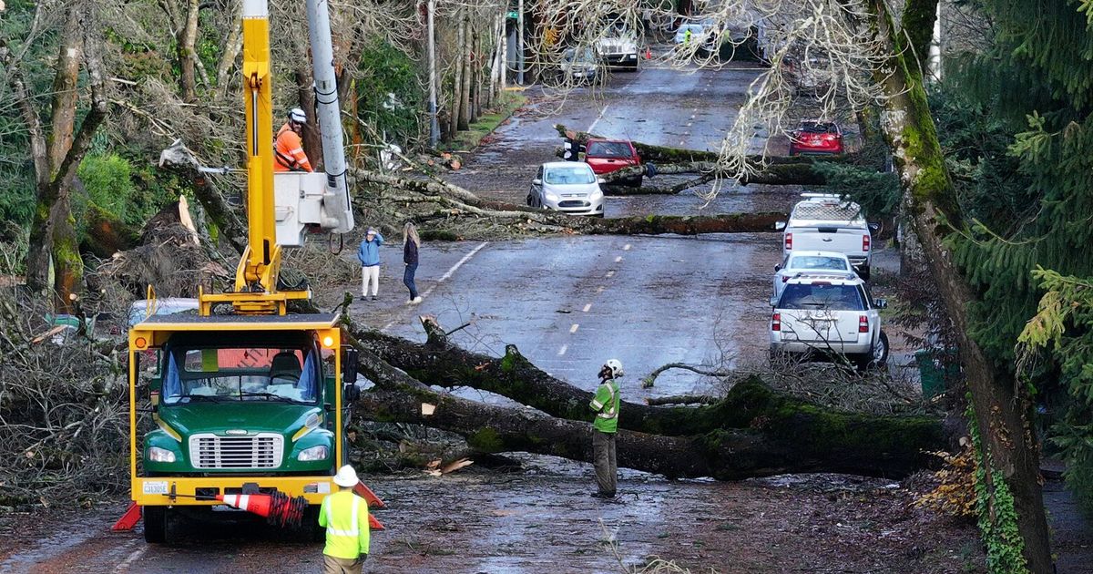
Just two weeks after Helene barreled across Florida as a Category 4 hurricane and ripped through five other states, Category 3 Hurricane Milton delivered a devastating follow-up to the Sunshine State. Although Florida is more than familiar with extreme weather events, the back-to-back nature of such powerful storms has strapped the resources of a state that was still reeling from the aftermath of the impact of Hurricane Debby two months ago.
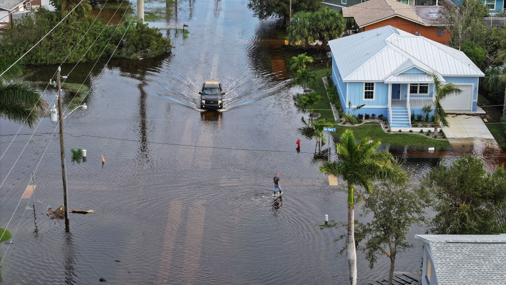
Helene proved the deadlier of the two storms, carrying devastating flooding to western North Carolina and eastern Tennessee and killing more than 200 people. As of Oct. 15, 92 people are still missing in North Carolina. In Florida, Milton ended up sparing a direct hit on Tampa that would have caused catastrophic, lethal flooding damage. Instead, the storm made landfall 70 miles south in Siesta Key, and its aftermath has killed at least 14 people. Milton left more than 3.2 million homes and businesses in the state without power, some of which had been without power since Helene hit.
Many scientists believe storms of this intensity presage our future on a hotter planet. An international group of scientists from the World Weather Attribution group released two reports, which have yet to be peer-reviewed, that suggests human-induced climate change helped fuel both Helene and Milton. Their analysis found recent record-high ocean temperatures intensified the storms' rainfall and wind speed, as hurricanes suck up their energy from warm water.
This hurricane season has also seen an onslaught of misinformation around the science of tropical cyclones themselves, and around the Federal Emergency Management Agency (FEMA), which controls disaster relief. This misinformation has been parroted by a variety of sources, including TikTok influencers and Elon Musk. Many Republican politicians, including Donald Trump, have attempted to use the hurricanes as a political weapon ahead of the election. In response, FEMA published a page on their website specifically debunking hurricane rumors and scams, for example that the agency's funding was diverted to support migrants at the border (a rumor spread by Trump) or that the agency was only giving out $750 to survivors (also spread by Trump).
This misinformation endangers the lives of storm survivors, who may be less likely to turn to FEMA for much-needed assistance. Last month, a cohort of nearly 100 Republican politicians, 11 of which represent Florida, voted against extending FEMA funding by $20 billion (the resolution passed, but still did not allocate enough funds to make it through the rest of hurricane season, per NPR). Now, some of those Republicans are demanding FEMA funds after their districts were impacted by the hurricanes, Rolling Stone reported. Per Politico, the federal government has already spent almost half of its allotted disaster relief for the next 12 months despite being just eight days into the fiscal year.
"There are people that suffered huge losses, that are still suffering without power, without water, from Helene and from Milton," said Kristen Corbosiero, an atmospheric scientist at the University at Albany. "That really should be the focus, instead of people who honestly don't know anything about science making things up about the science."
"It's frustrating, to say the least," said Athena Masson, a meteorologist and hurricane expert at Jacksonville University. "We're kind of in a time that experts are not considered experts anymore," she added.
I spoke with Corbosiero and Masson about the climate science behind the back-to-back lashings of Helene and Milton, the rise of misinformation, and what we might learn for the hurricanes of the future.
These interviews have been edited and condensed for clarity.
What has it been like being a hurricane expert in Florida the past few weeks?
Athena Masson: Very busy, very little sleep. But I would not have chosen this profession if I couldn't handle it.
I'm located in St. Augustine, Florida. Not in the direct path, but we still got some impacts, especially with Milton. The St. Augustine area, it's super coastal. The joke of the whole city is that you can tip a glass of water and it'll flood. But we got that northeast quadrant from Milton, that three-to-five foot storm surge, so the city right now is still cleaning up. Even downtown is still flooded because of that surge and because of that coastal flooding. We've also been having sewer problems and sewer backups. But nothing like down in the Tampa area.
The National Oceanic and Atmospheric Administration (NOAA) forecasted 2024 to be an above-normal year for the Atlantic hurricane system. What factors led to this prediction?
Masson: We've been having very warm sea surface temperatures, not just during the hurricane season, but also way back in the winter season as well. They just did not lower as much, and that's because ocean water does not like to change its temperature very, very rapidly. If it's very warm, it likes to store that heat. All that heat from past summers just continues to linger in the oceans, especially the Gulf of Mexico. By the time that hurricane season came, we were already warm. So as summer's approaching, now the oceans are just getting warmer and warmer. Hurricanes need at least sea surface temperatures of 80 degrees Fahrenheit or 26.5 degrees Celsius in order to form and evolve and grow. And we have had that for months and months. That's the main ingredient. So that caused NOAA and a whole bunch of other hurricane forecasters to kind of raise that alarm and say, hey, we are expecting the potential for another active hurricane season.
How did Helene and Milton live up to their storm predictions? Were they as destructive and dangerous as reports suggested they would be?
Corbosiero: They were both really, really well forecast in terms of where they eventually made landfall. Those forecasts four, five, six, almost seven days out were very, very good in terms in terms of where the storm would make landfall with very, very small—in terms of tens of miles—of difference.
In terms of intensity, Helene was very, very well forecast. Milton thankfully came ashore maybe slightly weaker than we potentially thought, but again the wind intensity, whether it was slightly higher or slightly lower, wasn't going to make a huge difference. In terms of destructiveness, we were more concerned about the water, both the storm surge and the amount of rain.
Masson: As far as track and forecast of where these hurricanes were going and their intensity levels when they were coming on shore, I think that the National Hurricane Center meteorologists did an excellent job with that.
Helene threw us off though—and this is a problem with the Saffir-Simpson Hurricane Wind Scale—when it went up into the Carolinas and up into Tennessee though. Just the massive destruction that you see in those areas, that's a concern and a problem that we as hurricane specialists need to address, because the Saffir-Simpson Hurricane Wind Scale does not take into account storm surge, rain, flooding, the size of a system. All that it says is the maximum amount of wind speeds that the storm has. So by the time it got into that area, it was designated as a tropical storm. No one takes a tropical storm seriously, or very few people do. Just when you hear tropical storm, no one pays attention to it, government officials don't pay attention to it, and that's when we're caught off guard. So that was a big problem with Helene.
Hurricane Helene and Milton arrived as this one-two punch, with not a lot of space in between them. How often does that happen? And how does that doubling affect the destruction that they cause?
Masson: It's common in the fact [that] we are in the middle of the peak of the Atlantic hurricane season. Generally, August, September, and October are peak months where we generally see the most amount of storms that are forming, and even our major hurricanes. The uncommon part, though, is how we were impacted in the state of Florida, this one-two punch in just a two-week time period. Yes, that is very uncommon.
The last time that we've had two Category 5s in a single hurricane season, that was all the way back in 2019 where we had Dorian and Lorenzo. It's very uncommon that you get two Category 5s in a hurricane season. It's very uncommon to even get a Category 5 in a hurricane season, because you have to have the right conditions that sustain and help this hurricane grow into that monster-type scenario and to keep it going for such a long period of time. You usually only see a Category 5 maybe come about like once every five years. But to be seeing Category 5 become so common lately? That's pretty interesting. [Ed. Note: In June 2024, Hurricane Beryl, became the first Category 5 hurricane of the season and the earliest of its kind recorded in the Atlantic.]
Corbosiero: It's fairly unprecedented that you would have two storms of such great intensity hit the same, very close area basically just a week apart. So that's unprecedented in our hurricane records, and obviously having a huge amount of rainfall fall in the same area, which didn't quite happen in this case—there was more rain in Florida for Milton, [and] there was more rainfall in the Carolinas with Helene—but I know that the locations just around Tampa and just north of Tampa were really hard hit by Helene, and then there was tons of just people trying to get stuff out of their houses, right? All of the stuff that was waterlogged on the streets, tons of damage and debris. So having storms back to back like that just makes it so much harder to clean things up for the recovery. So just really the worst-case scenario.
Misinformation can be a huge issue around any extreme weather event, but it seems like Milton and Helene have been accompanied by a lot of disinformation, such as that the storms were created by the government and steered toward Republican districts or that FEMA agents are part of a government plot. In your experience, how does the misinformation this hurricane season compare to those past?
Masson: It's getting worse. It's exhausting, it's sad and disheartening, because really, the ones who are trying to warn people way ahead of government officials, way ahead of FEMA, are the meteorologists. We all took an oath when [we became] meteorologists that we want to protect the public.
I do kind of want to blame social media to a certain extent, with all the false lies that go around and the misinformation. I think we're kind of in a time that experts are not considered experts anymore, that people would like to listen to a TikToker or someone with heavy amounts of views that are going out and risking their own lives to get their clicks in the storm, instead of the meteorologists that are behind the screen in their studios.
I think [social media] is a powerful tool for good, but I also think it's a very thin line we are walking along with it, because there's just so much information that is not correct on there, and I think a lot of people are just putting out this type of hype information to get views and clicks and to monetize upon it. So I think there needs to be better restrictions on social media in that aspect.
Corbosiero: It feels a lot worse, because I think it came from almost two angles here. There was a lot of misinformation about FEMA and what they were doing, their responsiveness, and what was available to people. But then there was also misinformation about the actual weather, about people controlling the weather, so it was almost from two sides. Unfortunately, I think that does have to do with the fact that we're just three weeks out from an election. I think that has a lot to do with it unfortunately.
It does seem to the misinformation seems to be coming from, unfortunately, one side of our two-party system. It feeds mistrust of science and of also of the government response. And it does seem to be politically motivated.
Do you have a sense of how much this disinformation trickles into actual politics and affects the lives of people on the ground?
Corbosiero: I've heard that, because of the FEMA misinformation, that people weren't applying for certain things because they had heard that they would only get a certain amount of money and maybe they deemed it wasn't worth it.
I don't think we'll know really what the consequences are of the misinformation, or what the outcome of that is, for a bit. But I do think that it does sow mistrust in science in general, and in specific, meteorologists. So it's really difficult. I saw somebody who's a TV meteorologist [say] that they're always getting a lot of flack because they can't predict the weather. Their forecasts are always wrong. But then it was like, oh, but now we can control [the weather]? If you stop and think about it, it's kind of mind-boggling. These two things don't go together. Do we think about that? And then also, "Oh, climate change isn't real because humans can't affect the atmosphere in that way, but you can control the weather." Let's stop and think about whether these two things make sense.
What do you think are the biggest challenges that people will face in the weeks ahead, recovering and rebuilding from these hurricanes?
Masson: Recovery will be long. Because it wasn't just with Helene. We did not finish the cleanup efforts at all with Helene. Now to add on top of that recovery effort the issues with Milton, especially along the West Coast in the Tampa area. And I am concerned about the insurance aspect of all of Florida. Because even prior to the season, insurance companies have been leaving Florida completely. We're down to just one type of insurance place that does cover most new homes, and that's [Citizens Property Insurance Corp]. And it's expensive.
So how are we going to rebuild when insurance companies are leaving? At this point I think that maybe our infrastructure might be suffering. People are going to be suffering. But how can we afford insurance, but also rising housing costs, but also rebuilding after these two hurricanes? This is a hurricane state. Florida is the hurricane state. We're going to get hit by a hurricane again, that's just fact. So as Floridians, what are we really to do?
Is there anything that we should be thinking about for the next month of hurricane season?
Corbosiero: As you said, it's not over. [The season] nominally ends the beginning, middle of November. But that's just sort of the standard dates. We've seen in recent years that storms have formed in later November into December. You know, the waters are still very, very warm. So people shouldn't let their guard down, right? We can have storms that can be destructive into later October and November. Anywhere along the, you know, the Gulf Coast or the Atlantic, it's still possible to have strong storms, make landfall. So, you know, keep an eye out and listen to what's going on.
Hurricanes seem slated to get more destructive with climate change, as they feed off of warming waters. What are the things that you're thinking about as temperatures continue to rise?
Corbosiero: We're still trying to figure it out. We're in this warm state. We seem to be seeing more destructive storms. But how it all shakes out, we're still trying to wrap our head around how much of the destructiveness can we attribute to global warming? How much is just natural variability? So as scientists, we're still all trying to parcel that out. But it's being aware and vigilant of hurricane season, and that kind of means, now, from April until December. The nominal hurricane season is, you know, May through November, but you know, adding on a few weeks on either side does seem to be a trend. So people in coastal communities really do need to be aware—and not even just coastal communities—that these storms come ashore and can produce devastating rainfall hundreds of miles inland. In a warming climate, we know that we have more extreme events, both hurricanes, but also other types of rainfall events. So people need to be paying attention to the weather.
Is there anything you think has been missing from the media coverage that you've seen of Hurricanes Helene and Milton?
Corbosiero: Our weather models, especially our hurricane models, were very, very good, and so that is a success right? We're predicting and we're modeling these storms so much better than we were two, three, five years ago.
Obviously if you have a better forecast, people can prepare at a longer lead time. But again, there's this distrust in the government and scientists in general. Maybe people don't believe the forecast. So maybe, if there was more attention paid to how great these forecasts were and how hard the scientists have worked to improve our models, and that's really a success story, then maybe people would believe the science more? I don't know.
Masson: I mean, there's so much going on. I think that emergency managers, meteorologists, the public, they're doing a good job getting the information out on areas that have been hardest hit, and people that do require assistance.
I still think that maybe the media could look at areas outside of just the immediate track of tropical storms and hurricanes, because we like to always focus and draw the attention to the exact impact, where that eyewall came ashore, which was just to the south of Tampa and the Sarasota region. It's heartbreaking to see that. But there's also larger areas way outside of that center that do require help. Helene was a good example. We were so focused on Helene and its maximum strength coming ashore, but then we sort of went away with the coverage, and didn't really focus so much on the Carolinas and Tennessee that saw just the immense amount of heartbreak and massive amounts of death within that area. So again, it's just important that just because the category of a hurricane is going down doesn't mean that the danger has left us at all. We should be tracking this all the way until that storm completely fizzles.
Comments( 0 )

0 0 0


0 0 2