Hurricane Milton Live Updates: Death Toll Climbs as Florida Assesses Storm Damage
Posted on 10/11/2024

Neither group’s analysis has undergone academic peer review yet. The first, by the World Weather Attribution research collaboration, relies on methods the group has used to estimate the influence of climate change on other extreme weather events, including Hurricane Helene last month.
Warmer air can take up more moisture. So as humans heat the planet, storms like Milton can carry larger cargoes of rain. Warmer seawater also imbues hurricanes with more energy as they traverse the ocean, allowing their winds to strengthen rapidly.
The second analysis, by researchers at Imperial College London, sought to estimate how much more economic loss a storm like Milton could cause compared with a similarly infrequent storm in an alternate version of today’s world, one with the same level of development and hurricane readiness, but without planet-warming emissions.
The researchers drew upon information from previous studies of how the property damage from past hurricanes that hit the United States varied in response to where the storms came ashore and their maximum wind speeds.
High winds aren’t the only cause of destruction during a hurricane: Flooding, storm surge and tornadoes matter, too. But small-seeming jumps in a hurricane’s wind speeds can translate into big increases in damage, said Ralf Toumi, a climate scientist at Imperial College London who worked on the analysis.
According to the National Oceanic and Atmospheric Administration, a hurricane’s potential damage in the United States rises by roughly a factor of four for every increase in the storm’s category rating. Milton made landfall this week as a Category 3 storm.
Think about it this way, Dr. Toumi said: In the chaos of a hurricane, the damage multiplies. The winds turn debris — or, say, the roof of your neighbor’s house — into flying projectiles.
“If that roof hits your roof, you’re in trouble,” Dr. Toumi said. “It’s just a cascading of problems.”
The resort still hasn’t recovered from the hurricane two years ago, and Mr. Niesel has been working to rebuild the property and reopen it to tourists. It has been under his family’s ownership for some 20 years.
He rushed to the resort as soon as officials opened the island to residents and business owners around 2:30 p.m.
“I’m all right,” he said. “There is cleanup to do, but for the most part, the structures held strong.”
Sanibel Island, off the coast of Southwest Florida, is renowned for its seashells and its commitment to environmental protection, with 70 percent of the island under conservation. The vast undeveloped tracts help to absorb storm water, but the island floods during storms of Milton’s magnitude.
Hurricane Milton left Sanibel in mixed condition overall. As of Thursday evening, low-lying areas remained underwater, while mounds of sand appeared like snowbanks along Sanibel-Captiva Road, a major island thoroughfare. The island remained without power and its wastewater system was down, though utility crews were hurrying to make repairs.
This year alone, Mr. Niesel has endured months of scares between Hurricanes Debby, Helene and Milton ever since breaking ground on the resort on March 28, his grandmother’s birthday.
“This whole summer has been storm prep — clean up, prep, clean up,” he said.
Wylie Griffin, 57, was supposed to have had the final inspection Thursday on her Sanibel Island home, which was finally ready for her to move back in after it was severely damaged in Hurricane Ian. She has been living with her mother for two years.
They battened down both of their Sanibel Island properties and evacuated to the mainland before Hurricane Milton arrived. To their relief and delight, the homes were OK when they were allowed back onto the island Thursday.
“It was dry,” Ms. Griffin said of her newly renovated home. “It’s unbelievable.”
On Thursday, as Hurricane Milton moved offshore into the Atlantic Ocean, officials and residents credited those warnings for getting people out of harm’s way. “We know lifesaving measures did make a difference,” President Biden said.
While waiting for a bridge to open and allow traffic back into Fort Myers Beach on Thursday, Jacki Liszak, the president of the town’s Chamber of Commerce, said she was focused not on the triple-whammy punch of Hurricanes Ian, Helene and Milton, but instead on what had gone right during this latest storm.
“When I write the script to this movie, nobody is going to believe it,” she said. “It’s insanity. But we’re going to take this as a win.”
Ms. Liszak, also a beach resident and business owner, said coordination among the town, Lee County and essential service providers was “night-and-day different” from the chaotic days in October 2022 after Hurricane Ian, which killed more than 100 people.
“I’m thrilled,” Ms. Liszak said. She had worked with the fire department to compile residential contact lists and to check in with those who had stayed, which she estimated as a few hundred, including employees at the resorts that stayed open. Most people who had lived through Hurricane Ian followed last weekend’s evacuation orders.
“Folks did a good job listening to the warnings,” Ms. Liszak said.
Jeff and Jennifer Rogers, both 60, chose to remain at their home in Port Charlotte, but they had family members from closer to the water come stay with them.
Ms. Rogers said she believed the early warnings made a difference, noting that she saw other residents preparing for the storm three or four days in advance, rather than waiting until the last minute.
“Locals took this one more seriously,” she said.
During the hurricane, the National Weather Service continued to push out warnings for those who had stayed behind. The Weather Service office for the Tampa Bay area issued a flash flood emergency on Wednesday night, warning those in Tampa and St. Petersburg to move to higher ground. An extreme wind warning was also issued for the area, which urged residents to shelter as if a tornado were approaching.
Ross Giarratana, a meteorologist with the Weather Service in Ruskin, Fla., said that meteorologists were monitoring conditions during the hurricane with the goal of giving residents an hour of lead time before dangerous winds or rising waters arrived.
“It’s kind of like a warning within a warning,” Mr. Giarratana said. “We hope that that’s lifesaving information for them to take action.”
At a news conference on Thursday, Mayor Castor thanked those who heeded warnings.
“I’m quite certain that that saved, if not lives, a lot of injuries,” she said.
Users posted scores of videos showing their homes flooding and their neighborhoods facing damage and destruction; they updated followers about their families and animals.
As with previous hurricanes, many Florida residents stayed, either because they felt their homes could withstand the storm, they had work obligations or gas was unavailable and plane tickets were too expensive. But this time, they broadcast their experiences from an app that seemed tailor-made to capture the unfolding chaos.
Logan Durrance, 29, of Polk County, was born and raised in Florida and familiar with the potential destructiveness of hurricanes. He and his family were on edge and thought about evacuating, but because their home is about 60 miles inland, they thought it might avoid the brunt of the storm. Mr. Durrance was also scheduled to work at a natural gas power plant in the area.
“There’s 24 hours before this hurricane gets here, but I’m already dedicated to work,” Mr. Durrance said on Thursday after 36 hours at the plant. “We had the house ready, boarding up windows, draining the pool.”
Mr. Durrance provided updates to his TikTok followers, who commented from around the country and the world to offer their support as he posted from the power plant in wind gusts and rain. Tornadoes touched down in his area, but his home was spared any major damage.
Like many of his followers, Mr. Durrance also looked to TikTok for live updates on what was happening across his state. “The roof had been ripped off Tropicana Field, and I was able to see it an hour before it was on Fox News,” he said.
“It’s a perspective you did not have in the past,” he added.
While some felt they had to stay, others, as many pointed out in comments, seemed to stay for the clicks.
A man who refused to leave his sailboat in Tampa became known as Lieutenant Dan for his defiance of evacuation orders, calling to mind a character in “Forrest Gump” who refused to abandon his boat in a storm. Another content creator, who normally posts about day trading, has racked up millions of views chronicling the storm from his Tampa high-rise apartment.
These broadcasts invite more interaction than a typical televised broadcast, with commenters writing that they were “praying so hard” for Lieutenant Dan, or pleading for the algorithm to bring them back for part two.
Morgan Roos, who had been posting periodic updates on Milton, garnered a particularly devoted fan base. One commenter wrote that they “came straight here to check on you this morning.” Another expressed their concern after a few hours of quiet: “I’m so worried about you. Please update us soon.”
Caroline Calloway, a social media influencer known for unorthodox ways of boosting engagement, was criticized for posting live updates of the storm from her house in Sarasota after refusing to evacuate. Instead, she took the opportunity to promote sales for her book.
But for those feeling the weight of the disaster, the TikTok audience can provide solace.
Mr. Durrance said that he was overwhelmed by the response from his followers as he provided updates during the storm.
“I could have never guessed that in a million years, that I have people that genuinely care about us as the way they do,” he said.
Here’s a look at five things that stood out this week.
One key part of the very first forecast was incredibly accurate.
Forecasters at the National Hurricane Center had one key piece of Milton’s puzzle correct at the start. When they issued their first forecast last Saturday, the anticipated path aligned almost precisely with where Milton ended up making landfall in Siesta Key, Fla. Historically, four days before landfall, the average error for a storm’s path is about 150 miles.
Over the next few days, the forecast path would nudge north and south, leaving residents fearful of vastly different potential impacts as the storm wobbled. People in Tampa, especially, grew increasingly worried about a worst-case scenario landfall north of Tampa Bay at high tide, which would have delivered a historically destructive storm surge.
Milton quickly became one of the strongest storms ever.
Forecasters did not have Milton’s intensity right on that first go, and they assumed the storm would be a strong Category 2 at landfall. But they started dialing in on the possibility of a major hurricane, a 3 or higher, a few hours later. And that is exactly what happened: From Sunday to Monday, Milton grew from a tropical storm to one of the strongest storms ever in the Gulf of Mexico.
By 8 p.m. on Monday, its wind speeds had increased to 180 miles per hour. Based on wind speed, it joined a handful of other hurricanes that rivaled the strongest Atlantic storm ever recorded: a 1980 hurricane named Allen, which had a peak wind speed of 190 m.p.h. before it made landfall along the United States-Mexico border.
Another way to measure a storm’s strength is by how low the pressure becomes inside it. As hurricane hunter aircraft moved through Milton’s pinhole eye on Monday evening, they recorded a near-record low pressure of 897 millibars, joining only five other Atlantic hurricanes to dip below 900 millibars: Allen, Rita, the Labor Day storm of 1935, Gilbert in 1988 and Wilma.
The intensity and strength of the storm at this point only heightened the anxiety along the coast and among meteorologists. On Monday, one of Florida’s most veteran meteorologists choked up on air in a video that went viral, as he feared what that dropping millibar reading would mean if the storm were to come ashore at that intensity.
But it did not. An eyewall replacement cycle forced the storm to weaken, as most Category 5 storms do, when a new wall of thunderstorms begins to form around the smaller inner eyewall, choking out its moisture source and creating a much larger eye of the hurricane. The resulting hurricane, larger but weaker, can bring the potential for damage to occur over a more widespread area with landfall.
Milton continued to chart its own course through the Gulf: Its evolution was short-lived, and on Tuesday, Milton became a Category 5 again, this time at its new larger size. It had become a catastrophic-looking monster, with an eye large and clear enough that you could see the ocean below.
Even as forecasters believed the storm would weaken again, which it did, emergency managers and other officials across the state had to prepare for the worst-case scenario that it would not.
Hurricanes produce tornadoes, but this was “quite a day.”
As the storm inched closer to land, meteorologists continued to forecast that it would lose its intensity, but that its hazards would still be intense. What surprised them on Wednesday, as the far outer bands began sweeping across the Florida peninsula, were the damaging and deadly tornadoes that tore long tracks through the state.
It’s not unusual for tornadoes to precede a storm’s landfall, but they are usually weak and short-lived. Those accompanying Milton were more intense — “a little out of the ordinary,” said Bill Bunting, with the Storm Prediction Center. The National Weather Service issued more than 100 tornado warnings on Wednesday, and trained spotters reported at least 38 tornado sightings.
Tornadoes Across Florida
Locations of tornado sightings or damage reported by trained spotters.
More than 100 structures were damaged before Milton came ashore on Wednesday, and local officials said at least five people were dead after a tornado moved through St. Lucie County, on the other side of the state from the Gulf Coast.
Milton became unbalanced just before landfall.
As night approached and Milton tracked closer to shore, it turned practically lopsided, with all the heavy rain on the northern side of the storm. An interaction with cooler and drier air steered the storm to the northeast, into Sarasota, which is why the storm weakened to a Category 3 hurricane at landfall, and spread its wind radius even farther out.
Despite the unbalanced look on weather satellite and radar, the winds were strong on both sides of the eye. To the south, a storm surge raged ashore, while in Tampa Bay, the winds pushed the water out for a brief period, creating a reverse surge. Had it not become unbalanced, the storm might have been able to carry its strength a while longer, and the effects could have been even more destructive.
The storm’s new shape affected who got the most rain.
The storm’s asymmetrical nature kept the excessive rainfall north of the center, running a path right along Interstate 4, drenching St. Petersburg, Tampa and Orlando. Up to 18 inches of rain fell during the storm in some places.
This shape, with an eroding southern section of the storm, wasn’t surprising. It’s almost precisely what happened with Helene two weeks ago, as that storm interacted with a more turbulent air mass and shifted the rain to the northern edge.
The back-to-back nature of these two destructive storms has left Florida residents fatigued, but forecasters were not surprised. A lot of this year could have looked like this, based on their earlier predictions that this season would be overly active. But a lull late in the summer had many wondering if those predictions were wrong. The past few weeks have proved otherwise: In addition to Helene and Milton, four other storms have formed and gone, with three of them reaching hurricane strength.
The hurricane season is now statistically above-average, especially in the number of hurricanes (nine) and major hurricanes (four). And now forecasters are worried that it isn’t over yet, with some suggesting it could even stretch into December, well after the official end of hurricane season on Nov. 30.
At least 13 deaths have been linked to Milton and hundreds of people have been rescued from hard-hit areas.
More than 2.4 million customers in Florida were still without power on Friday morning as emergency crews continued restoration efforts throughout the state.
Here’s how Milton affected different regions of the state.
Tampa Bay was spared from the worst of the storm surge but still was damaged by wind and rain.
The Tampa Bay region did not experience disastrous storm surge, which many forecasters feared. Still, there was serious flooding in many communities along the west coast, where as much as 18 inches of rain fell, and some areas were battered.
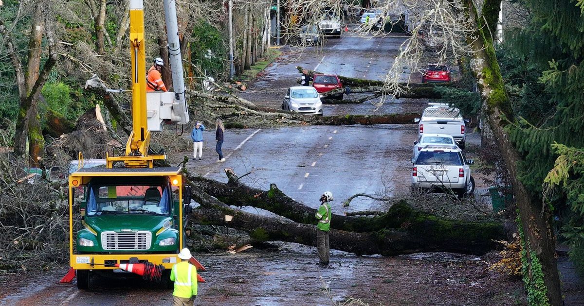
Before-and-after images taken along the Gulf Coast showed residential streets and lawns under water, and fallen trees and debris scattered about.
In Sarasota, Clearwater and other communities, rescuers pulled people from flooded or damaged buildings and vehicles.
And in St. Petersburg, gusts of more than 100 miles per hour tore the roof off the Tampa Bay Rays’ Tropicana Field baseball stadium and smashed a 500-foot crane onto a building occupied by the Tampa Bay Times newspaper. The water system was another problem the city faced on Thursday — many residents were advised to boil their water until crews made repairs.
Areas of Central Florida suffered flooding.
Significant flooding from swollen rivers and extensive power outages occurred in Central Florida after Milton moved over the region on Wednesday night.
Some counties were still almost entirely without power on Thursday evening. In Highlands County, 93 percent of customers did not have electricity.
Still, officials in the region said it had escaped catastrophe. In Orlando, Milton left its mark in the form of downed street poles and trees. More than 120,000 customers were still without power in Orange County, which includes Orlando, as of Thursday evening.
Some areas of Central Florida saw 10 to 15 inches of rain, the National Weather Service said, adding that it could take days for the water in rivers and flooded areas to subside.
There were damaging tornadoes on the east coast.
Tornadoes spawned by Milton killed at least six people in St. Lucie County on the eastern side of the state and damaged dozens of homes in Martin County to the south of St. Lucie.
Some of the victims resided at Spanish Lakes Country Club Village, according to the victims’ family members, a retirement community of mobile homes north of Fort Pierce.
Many coastal communities on this side of the peninsula were also still reeling from the deluge of rain and surging tides on Thursday.
Officials in Volusia County, which includes Daytona Beach, were still trying on Thursday to reach people who were left stranded in homes in areas cut off by flooded roadways. Also in that county, the sheriff’s office confirmed that four deaths were linked to the storm, including two people who died after trees fell on homes.
Patricia Mazzei , Jenna Russell , Kate Selig , Nicholas Bogel-Burroughs , Annie Correal and Jennifer Reed contributed reporting.
Warmer air can take up more moisture. So as humans heat the planet, storms like Milton can carry larger cargoes of rain. Warmer seawater also imbues hurricanes with more energy as they traverse the ocean, allowing their winds to strengthen rapidly.
The second analysis, by researchers at Imperial College London, sought to estimate how much more economic loss a storm like Milton could cause compared with a similarly infrequent storm in an alternate version of today’s world, one with the same level of development and hurricane readiness, but without planet-warming emissions.
The researchers drew upon information from previous studies of how the property damage from past hurricanes that hit the United States varied in response to where the storms came ashore and their maximum wind speeds.
High winds aren’t the only cause of destruction during a hurricane: Flooding, storm surge and tornadoes matter, too. But small-seeming jumps in a hurricane’s wind speeds can translate into big increases in damage, said Ralf Toumi, a climate scientist at Imperial College London who worked on the analysis.
According to the National Oceanic and Atmospheric Administration, a hurricane’s potential damage in the United States rises by roughly a factor of four for every increase in the storm’s category rating. Milton made landfall this week as a Category 3 storm.
Think about it this way, Dr. Toumi said: In the chaos of a hurricane, the damage multiplies. The winds turn debris — or, say, the roof of your neighbor’s house — into flying projectiles.
“If that roof hits your roof, you’re in trouble,” Dr. Toumi said. “It’s just a cascading of problems.”
The resort still hasn’t recovered from the hurricane two years ago, and Mr. Niesel has been working to rebuild the property and reopen it to tourists. It has been under his family’s ownership for some 20 years.
He rushed to the resort as soon as officials opened the island to residents and business owners around 2:30 p.m.
“I’m all right,” he said. “There is cleanup to do, but for the most part, the structures held strong.”
Sanibel Island, off the coast of Southwest Florida, is renowned for its seashells and its commitment to environmental protection, with 70 percent of the island under conservation. The vast undeveloped tracts help to absorb storm water, but the island floods during storms of Milton’s magnitude.
Hurricane Milton left Sanibel in mixed condition overall. As of Thursday evening, low-lying areas remained underwater, while mounds of sand appeared like snowbanks along Sanibel-Captiva Road, a major island thoroughfare. The island remained without power and its wastewater system was down, though utility crews were hurrying to make repairs.
This year alone, Mr. Niesel has endured months of scares between Hurricanes Debby, Helene and Milton ever since breaking ground on the resort on March 28, his grandmother’s birthday.
“This whole summer has been storm prep — clean up, prep, clean up,” he said.
Wylie Griffin, 57, was supposed to have had the final inspection Thursday on her Sanibel Island home, which was finally ready for her to move back in after it was severely damaged in Hurricane Ian. She has been living with her mother for two years.
They battened down both of their Sanibel Island properties and evacuated to the mainland before Hurricane Milton arrived. To their relief and delight, the homes were OK when they were allowed back onto the island Thursday.
“It was dry,” Ms. Griffin said of her newly renovated home. “It’s unbelievable.”
On Thursday, as Hurricane Milton moved offshore into the Atlantic Ocean, officials and residents credited those warnings for getting people out of harm’s way. “We know lifesaving measures did make a difference,” President Biden said.
While waiting for a bridge to open and allow traffic back into Fort Myers Beach on Thursday, Jacki Liszak, the president of the town’s Chamber of Commerce, said she was focused not on the triple-whammy punch of Hurricanes Ian, Helene and Milton, but instead on what had gone right during this latest storm.
“When I write the script to this movie, nobody is going to believe it,” she said. “It’s insanity. But we’re going to take this as a win.”
Ms. Liszak, also a beach resident and business owner, said coordination among the town, Lee County and essential service providers was “night-and-day different” from the chaotic days in October 2022 after Hurricane Ian, which killed more than 100 people.
“I’m thrilled,” Ms. Liszak said. She had worked with the fire department to compile residential contact lists and to check in with those who had stayed, which she estimated as a few hundred, including employees at the resorts that stayed open. Most people who had lived through Hurricane Ian followed last weekend’s evacuation orders.
“Folks did a good job listening to the warnings,” Ms. Liszak said.
Jeff and Jennifer Rogers, both 60, chose to remain at their home in Port Charlotte, but they had family members from closer to the water come stay with them.
Ms. Rogers said she believed the early warnings made a difference, noting that she saw other residents preparing for the storm three or four days in advance, rather than waiting until the last minute.
“Locals took this one more seriously,” she said.
During the hurricane, the National Weather Service continued to push out warnings for those who had stayed behind. The Weather Service office for the Tampa Bay area issued a flash flood emergency on Wednesday night, warning those in Tampa and St. Petersburg to move to higher ground. An extreme wind warning was also issued for the area, which urged residents to shelter as if a tornado were approaching.
Ross Giarratana, a meteorologist with the Weather Service in Ruskin, Fla., said that meteorologists were monitoring conditions during the hurricane with the goal of giving residents an hour of lead time before dangerous winds or rising waters arrived.
“It’s kind of like a warning within a warning,” Mr. Giarratana said. “We hope that that’s lifesaving information for them to take action.”
At a news conference on Thursday, Mayor Castor thanked those who heeded warnings.
“I’m quite certain that that saved, if not lives, a lot of injuries,” she said.
Users posted scores of videos showing their homes flooding and their neighborhoods facing damage and destruction; they updated followers about their families and animals.
As with previous hurricanes, many Florida residents stayed, either because they felt their homes could withstand the storm, they had work obligations or gas was unavailable and plane tickets were too expensive. But this time, they broadcast their experiences from an app that seemed tailor-made to capture the unfolding chaos.
Logan Durrance, 29, of Polk County, was born and raised in Florida and familiar with the potential destructiveness of hurricanes. He and his family were on edge and thought about evacuating, but because their home is about 60 miles inland, they thought it might avoid the brunt of the storm. Mr. Durrance was also scheduled to work at a natural gas power plant in the area.
“There’s 24 hours before this hurricane gets here, but I’m already dedicated to work,” Mr. Durrance said on Thursday after 36 hours at the plant. “We had the house ready, boarding up windows, draining the pool.”
Mr. Durrance provided updates to his TikTok followers, who commented from around the country and the world to offer their support as he posted from the power plant in wind gusts and rain. Tornadoes touched down in his area, but his home was spared any major damage.
Like many of his followers, Mr. Durrance also looked to TikTok for live updates on what was happening across his state. “The roof had been ripped off Tropicana Field, and I was able to see it an hour before it was on Fox News,” he said.
“It’s a perspective you did not have in the past,” he added.
While some felt they had to stay, others, as many pointed out in comments, seemed to stay for the clicks.
A man who refused to leave his sailboat in Tampa became known as Lieutenant Dan for his defiance of evacuation orders, calling to mind a character in “Forrest Gump” who refused to abandon his boat in a storm. Another content creator, who normally posts about day trading, has racked up millions of views chronicling the storm from his Tampa high-rise apartment.
These broadcasts invite more interaction than a typical televised broadcast, with commenters writing that they were “praying so hard” for Lieutenant Dan, or pleading for the algorithm to bring them back for part two.
Morgan Roos, who had been posting periodic updates on Milton, garnered a particularly devoted fan base. One commenter wrote that they “came straight here to check on you this morning.” Another expressed their concern after a few hours of quiet: “I’m so worried about you. Please update us soon.”
Caroline Calloway, a social media influencer known for unorthodox ways of boosting engagement, was criticized for posting live updates of the storm from her house in Sarasota after refusing to evacuate. Instead, she took the opportunity to promote sales for her book.
But for those feeling the weight of the disaster, the TikTok audience can provide solace.
Mr. Durrance said that he was overwhelmed by the response from his followers as he provided updates during the storm.
“I could have never guessed that in a million years, that I have people that genuinely care about us as the way they do,” he said.
Here’s a look at five things that stood out this week.
One key part of the very first forecast was incredibly accurate.
Forecasters at the National Hurricane Center had one key piece of Milton’s puzzle correct at the start. When they issued their first forecast last Saturday, the anticipated path aligned almost precisely with where Milton ended up making landfall in Siesta Key, Fla. Historically, four days before landfall, the average error for a storm’s path is about 150 miles.
Over the next few days, the forecast path would nudge north and south, leaving residents fearful of vastly different potential impacts as the storm wobbled. People in Tampa, especially, grew increasingly worried about a worst-case scenario landfall north of Tampa Bay at high tide, which would have delivered a historically destructive storm surge.
Milton quickly became one of the strongest storms ever.
Forecasters did not have Milton’s intensity right on that first go, and they assumed the storm would be a strong Category 2 at landfall. But they started dialing in on the possibility of a major hurricane, a 3 or higher, a few hours later. And that is exactly what happened: From Sunday to Monday, Milton grew from a tropical storm to one of the strongest storms ever in the Gulf of Mexico.
By 8 p.m. on Monday, its wind speeds had increased to 180 miles per hour. Based on wind speed, it joined a handful of other hurricanes that rivaled the strongest Atlantic storm ever recorded: a 1980 hurricane named Allen, which had a peak wind speed of 190 m.p.h. before it made landfall along the United States-Mexico border.
Another way to measure a storm’s strength is by how low the pressure becomes inside it. As hurricane hunter aircraft moved through Milton’s pinhole eye on Monday evening, they recorded a near-record low pressure of 897 millibars, joining only five other Atlantic hurricanes to dip below 900 millibars: Allen, Rita, the Labor Day storm of 1935, Gilbert in 1988 and Wilma.
The intensity and strength of the storm at this point only heightened the anxiety along the coast and among meteorologists. On Monday, one of Florida’s most veteran meteorologists choked up on air in a video that went viral, as he feared what that dropping millibar reading would mean if the storm were to come ashore at that intensity.
But it did not. An eyewall replacement cycle forced the storm to weaken, as most Category 5 storms do, when a new wall of thunderstorms begins to form around the smaller inner eyewall, choking out its moisture source and creating a much larger eye of the hurricane. The resulting hurricane, larger but weaker, can bring the potential for damage to occur over a more widespread area with landfall.
Milton continued to chart its own course through the Gulf: Its evolution was short-lived, and on Tuesday, Milton became a Category 5 again, this time at its new larger size. It had become a catastrophic-looking monster, with an eye large and clear enough that you could see the ocean below.
Even as forecasters believed the storm would weaken again, which it did, emergency managers and other officials across the state had to prepare for the worst-case scenario that it would not.
Hurricanes produce tornadoes, but this was “quite a day.”
As the storm inched closer to land, meteorologists continued to forecast that it would lose its intensity, but that its hazards would still be intense. What surprised them on Wednesday, as the far outer bands began sweeping across the Florida peninsula, were the damaging and deadly tornadoes that tore long tracks through the state.
It’s not unusual for tornadoes to precede a storm’s landfall, but they are usually weak and short-lived. Those accompanying Milton were more intense — “a little out of the ordinary,” said Bill Bunting, with the Storm Prediction Center. The National Weather Service issued more than 100 tornado warnings on Wednesday, and trained spotters reported at least 38 tornado sightings.
Tornadoes Across Florida
Locations of tornado sightings or damage reported by trained spotters.
More than 100 structures were damaged before Milton came ashore on Wednesday, and local officials said at least five people were dead after a tornado moved through St. Lucie County, on the other side of the state from the Gulf Coast.
Milton became unbalanced just before landfall.
As night approached and Milton tracked closer to shore, it turned practically lopsided, with all the heavy rain on the northern side of the storm. An interaction with cooler and drier air steered the storm to the northeast, into Sarasota, which is why the storm weakened to a Category 3 hurricane at landfall, and spread its wind radius even farther out.
Despite the unbalanced look on weather satellite and radar, the winds were strong on both sides of the eye. To the south, a storm surge raged ashore, while in Tampa Bay, the winds pushed the water out for a brief period, creating a reverse surge. Had it not become unbalanced, the storm might have been able to carry its strength a while longer, and the effects could have been even more destructive.
The storm’s new shape affected who got the most rain.
The storm’s asymmetrical nature kept the excessive rainfall north of the center, running a path right along Interstate 4, drenching St. Petersburg, Tampa and Orlando. Up to 18 inches of rain fell during the storm in some places.
This shape, with an eroding southern section of the storm, wasn’t surprising. It’s almost precisely what happened with Helene two weeks ago, as that storm interacted with a more turbulent air mass and shifted the rain to the northern edge.
The back-to-back nature of these two destructive storms has left Florida residents fatigued, but forecasters were not surprised. A lot of this year could have looked like this, based on their earlier predictions that this season would be overly active. But a lull late in the summer had many wondering if those predictions were wrong. The past few weeks have proved otherwise: In addition to Helene and Milton, four other storms have formed and gone, with three of them reaching hurricane strength.
The hurricane season is now statistically above-average, especially in the number of hurricanes (nine) and major hurricanes (four). And now forecasters are worried that it isn’t over yet, with some suggesting it could even stretch into December, well after the official end of hurricane season on Nov. 30.
At least 13 deaths have been linked to Milton and hundreds of people have been rescued from hard-hit areas.
More than 2.4 million customers in Florida were still without power on Friday morning as emergency crews continued restoration efforts throughout the state.
Here’s how Milton affected different regions of the state.
Tampa Bay was spared from the worst of the storm surge but still was damaged by wind and rain.
The Tampa Bay region did not experience disastrous storm surge, which many forecasters feared. Still, there was serious flooding in many communities along the west coast, where as much as 18 inches of rain fell, and some areas were battered.
Before-and-after images taken along the Gulf Coast showed residential streets and lawns under water, and fallen trees and debris scattered about.
In Sarasota, Clearwater and other communities, rescuers pulled people from flooded or damaged buildings and vehicles.
And in St. Petersburg, gusts of more than 100 miles per hour tore the roof off the Tampa Bay Rays’ Tropicana Field baseball stadium and smashed a 500-foot crane onto a building occupied by the Tampa Bay Times newspaper. The water system was another problem the city faced on Thursday — many residents were advised to boil their water until crews made repairs.
Areas of Central Florida suffered flooding.
Significant flooding from swollen rivers and extensive power outages occurred in Central Florida after Milton moved over the region on Wednesday night.
Some counties were still almost entirely without power on Thursday evening. In Highlands County, 93 percent of customers did not have electricity.
Still, officials in the region said it had escaped catastrophe. In Orlando, Milton left its mark in the form of downed street poles and trees. More than 120,000 customers were still without power in Orange County, which includes Orlando, as of Thursday evening.
Some areas of Central Florida saw 10 to 15 inches of rain, the National Weather Service said, adding that it could take days for the water in rivers and flooded areas to subside.
There were damaging tornadoes on the east coast.
Tornadoes spawned by Milton killed at least six people in St. Lucie County on the eastern side of the state and damaged dozens of homes in Martin County to the south of St. Lucie.
Some of the victims resided at Spanish Lakes Country Club Village, according to the victims’ family members, a retirement community of mobile homes north of Fort Pierce.
Many coastal communities on this side of the peninsula were also still reeling from the deluge of rain and surging tides on Thursday.
Officials in Volusia County, which includes Daytona Beach, were still trying on Thursday to reach people who were left stranded in homes in areas cut off by flooded roadways. Also in that county, the sheriff’s office confirmed that four deaths were linked to the storm, including two people who died after trees fell on homes.
Patricia Mazzei , Jenna Russell , Kate Selig , Nicholas Bogel-Burroughs , Annie Correal and Jennifer Reed contributed reporting.
Comments( 0 )

0 0 0


0 0 2