
Potential Tropical Cyclone 8 dumps more than 20 inches of rain on Carolina Beach
Posted on 09/17/2024

When the sun rose Tuesday morning, the extent of the damage done by Potential Tropical Cyclone 8 became clear.
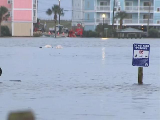
Monday was a WRAL Weather Alert Day because Potential Tropical Cyclone 8 brought heavy rain, strong winds and the risk of tornadoes, flooding and power outages to North Carolina. Southeastern North Carolina was hit the hardest, especially the coastal communities that make up much of the area.
The most significant impacts from PTC 8 were felt during the second half of Monday – particularly along the coast. Carolina Beach received more than 20 inches of rain since Sunday night, resulting in life-threatening flooding. It's being called an extremely rare 1,000-year flood.
Flood watches and flash flood warnings were issued for several counties Monday until Tuesday morning. They have expired, but you'll still want to watch out for flooded roads and standing water.
Tropical storm warnings were in effect along the North Carolina coast Monday and there were also several tornado warnings.
A final recording on Tuesday afternoon showed Carolina Beach had seen 20.81 inches of rain since Sunday. Elsewhere in Brunswick County, Southport (19.13 inches) and St. James (18.65) also were hit hard. Standing water was seen along some main roads, including Lake Park Boulevard.
Downed trees leave thousands without power in NC
On Monday afternoon, winds reached speeds up to 30 mph, saturating the ground and bringing down trees. There were thousands of power outages in eastern North Carolina on Tuesday morning.
Tuesday just before 2 a.m., WRAL News received reports of a downed tree on Whitman Road in Raleigh.
WRAL News has received several reports of downed trees across the Triangle Tuesday morning.
Wade Avenue was closed between Dixie Trail and Faircloth Street in Raleigh after a tree took down the power lines – snapping a power pole in half and leaving many residents without power. Duke Energy said power should be back on by 4 p.m.
Flooding, washouts make roads impassable
Around 4:20 a.m., the North Carolina Department of Transportation (NC DOT) said part of Interstate 95 North was closed at Exit 77 (Hodges Chapel Road). The NC DOT deemed the road impassable, but it reopened around 7:20 a.m.
At 6 a.m., the NC DOT reported a crash in this spot on I-95 North at Exit 77.
NC 12 at Ocracoke Island will not reopen on Tuesday. Crews will reassess after Wednesday morning's high tide.
"We're bringing in crews from our other five counties to converge into Brunswick County," said Battle Whitley with NC DOT. "We're assessing as we go. We're trying to get to locations and barricade them so people won't drive through high water and things like that."
The NC DOT has reported five crashes on Interstate 40 so far Tuesday morning. Three crashes happened in less than 30 minutes along a 9-mile stretch of the interstate in Durham County.
In Fayetteville, Ramsey Street remains closed near Drake Street Tuesday morning because of flooding. This road is known to flood during and after storms. Drivers can use Hillsboro Street as a detour.
Please remember that it's not safe to try and drive through flooded roads; take an alternate route instead.
You can tune into WRAL News+ or 101.5FM in the Triangle for traffic updates.
Severe flooding from this storm left several people stranded on U.S. Highway 17 in Brunswick County Monday afternoon.
Due to major flooding, Brunswick County issued a curfew for the unincorporated areas until Tuesday at 7 a.m.
Flooding will still pose a threat after the curfew is lifted. There's more rain in the forecast Tuesday, so please use caution when driving in the area.
Southport also experienced road washouts Monday, with major roads rendered impassable due to the storm’s impacts.
At the coast, many people were seen out assisting business owners and residents with cleanup efforts.
"It was definitely rough, you couldn't see," said Breck Price with The Starlite Inn in Carolina Beach. There were no guests staying at the hotel Monday night. A nearby sushi bar in town had a lot of flooding.
In a Facebook post, Southport Police Department wrote:
"Please stay off the road if at all possible – major road washouts – this is river rd between the tiger mart and 50 lakes drive – dangerous conditions – impassable conditions on river rd."
Several businesses closed
Several businesses along the coast said they were closed due to flood waters. While much of the flooding receded Tuesday, many said they were unable to open their doors on Tuesday.
The closed businesses are as follows:
Crush & Grind
Kate's Pancake House
Hang Ten Grill
The Veggie Wagon
School delays Tuesday
Several schools dismissed early on Monday due to the inclement weather.
School delays on Tuesday are as follows:
Ascend Leadership Academy
Central Carolina CC
Duplin County Schools
Harnett County Schools
Hoke County Schools
Lee County Schools
Little Beginningz Learning
Little Dolphins/Clinton
New Breed Christian CCC
New Life Christian Academy
Northampton Co Schools
Northwood Temple Academy
S Wake Preschool & Academy
Sampson Community College
STARS Charter School
Stedman BC Day Care
The Ark Child Care in Clinton
Tom Thumb Academy in Salemburg
Trinity Child Care in Fayetteville
Trinity Christian School
Wayne County Schools
Click here to see what time these schools will start Tuesday.
Helpful links: Sign up for WRAL weather alerts | Live DUALDoppler5000 | Wind speeds and wind gusts | Live cams across NC | WRAL interactive hurricane tracker
Tree falls on Fayetteville home
A Fayetteville resident had a massive tree fall on her house Monday.
This happened on Broadfoot Avenue in the Haymount neighborhood. Fortunately, no injuries were reported.
"Part of the roof is gone, and it's fallen all the way onto the front porch," said homeowner Sharon Moyer.
Flooding poses biggest threat, emergency crews on standby
Flooding is often the most dangerous part of a storm.
"Water is one of the most powerful forces on Earth. Even a small amount of rain or floodwater on a roadway can be devastating," said Darshan Patel, operations manager for Wake County Emergency Management.
Patel said, with the ground already saturated from this week’s rain, flooding could easily occur in low-lying areas.
"We’re working closely with our partners to assess potential public safety concerns. If risks are identified, we’re ready to take proactive measures," he said.
Crews are also monitoring road conditions and power lines.
"It’s a constant challenge with Mother Nature," said Jeff Brooks, Duke Energy spokesperson. "Soggy ground makes it even harder to prevent outages caused by falling trees, but we’re doing everything we can to minimize disruptions."
Duke Energy is keeping its current teams on standby and is prepared to deploy them to critical areas if needed. Although summer is winding down, the peak of tropical storm season is just beginning.
"This system developed quickly off the coast and will bring nasty weather over the next few days," Brooks said. "We might see more storms like this soon."
For local safety updates, residents are encouraged to use ReadyWake, a mobile resource that provides notifications about potential hazards in their area.
Information on road closures is also available on DriveNC, which has added a "Potential tropical cyclone" tab on their website. Users can toggle on and off to see specific impacts from this storm on the roads.
Governor Cooper urges caution
Governor Roy Cooper posted on X, urging residents to stay safe.
"Significant flooding is impacting Southeast NC as heavy rain continues," he said. "We're in contact with local officials, and @NCEmergency is assisting coastal communities in their storm response.
"Stay safe and follow guidance from local emergency officials."
Comments( 0 )
:quality(70)/cloudfront-us-east-1.images.arcpublishing.com/adn/JF6FH7DLYVBLZMKLMUUM52A2CI.JPG)

0 0 0


0 0 2


