Hurricane Helene A Surge, Flood, High Wind Danger
Posted on 09/26/2024

Hurricane Helene is rapidly intensifying, growing in size and forecast to deliver a potentially catastrophic strike on Florida's Gulf Coast on Thursday with possible record storm surge, destructive winds and flooding rainfall.
The impacts from Helene won't stop at the coast. Life-threatening flash flooding, damaging winds and some tornadoes will also spread well inland into parts of the Southeast.
(MORE: Map Tracker)
Where is it now: Helene became the fifth hurricane of the 2024 Atlantic hurricane season late Wednesday morning. It is centered just over 400 miles southwest of Tampa, Florida, and is tracking north. Maximum sustained winds are 85 mph.
The storm is slowly pulling away from Mexico's Yucatan Peninsula, but still drenching western Cuba. Wind gusts to 69 mph have been measured at Isla Mujeres, an island just northeast of Cancún, and parts of western Cuba have picked up over 7 inches of rain, so far.
Meanwhile, bands of heavy rain have developed well ahead of Helene over parts of the Southeast U.S., prompting occasional flash flood warnings as far north as southwest Virginia. Several roads were already flooded Wednesday afternoon in parts of Greene and Sevier Counties in eastern Tennessee.
Watches and warnings in effect: A hurricane warning is in effect from Florida's Big Bend and Nature Coast into southwest Georgia, including Tallahassee. Storm surge warnings extend from Mexico Beach southward to Flamingo, including Tampa Bay and Charlotte Harbor.
As shown in the map below, tropical storm warnings cover almost the entire rest of Florida and Georgia not covered by hurricane warnings, all of South Carolina and much of western North Carolina.
These alerts mean hurricane, tropical storm and storm surge conditions are expected in these areas as Helene moves in.
Interests in the warned areas should implement their hurricane plans and heed any advice from local emergency managers.
Here is the timeline:
- Thursday: Helene is expected to reach its peak intensity in the eastern Gulf and then make a landfall somewhere along the Gulf Coast of Florida as a large, intense hurricane Thursday night. That landfall is most likely to happen in Florida's Big Bend or eastern Panhandle region, but its impacts (surge, winds, rain) will happen far from the center, typical for larger storms.
- Friday: Helene will sweep quickly northward through the Southeast toward the southern Appalachians and Ohio Valley with strong, possibly damaging wind gusts, flooding rain and isolated tornadoes.
(Further beef up your forecast with our detailed, hour-by-hour breakdown for the next 8 days – only available on our Premium Pro experience.)
How strong could it become: Helene will likely become a major hurricane in the Gulf ahead of landfall.
That's because heat content is one favorable ingredient for intensification, and the map below Helene is headed for a reservoir of deep, warm water known as the Gulf of Mexico's loop current. In fact, Gulf of Mexico heat content is at record high levels for this time of year, according to University of Miami tropical scientist Brian McNoldy.
One other factor to consider is wind shear. Wind shear typically limits or weakens tropical storms and hurricanes by either tilting their circulation or blowing more thunderstorms away from its core.
Lower wind shear will allow Helene to fully take advantage of that deep, warm water. Some increase in shear may arrive near landfall, but by that time, it will likely be an intense, large hurricane.
(For even more granular weather data tracking in your area, view your 15-minute details forecast in our Premium Pro experience.)
U.S. Impacts
Storm Surge
The National Hurricane Center's storm surge forecast is shown in the embedded post below. As you can see, much of the Florida Gulf Coast is expected to see at least some storm surge flooding, including areas as far south as the Keys.
However, a potentially catastrophic storm surge is expected along and to the east of where Helene's center makes landfall in Florida's Big Bend, Apalachee Bay and Nature Coast. Some surge inundation of 10 to 20 feet above ground level is forecast in these areas. For Cedar Key, that would top a record storm surge set 128 years ago, and could be at least twice the surge inundation from Hurricane Idalia in August 2023 (6.84 feet).
Given Helene's anticipated large wind field, significant storm surge flooding is also expected in the Tampa-St. Pete-Sarasota metro areas that is expected to be several feet higher than what was experienced over a year ago with Hurricane Idalia.
If you live near the coast, know your evacuation zone and heed any orders from local emergency management.
Winds
As alluded to earlier, Helene will be both a large, intense and fast-moving hurricane in the Gulf and then will plow inland. That means its strong winds will cover a larger area and push farther inland than usual.
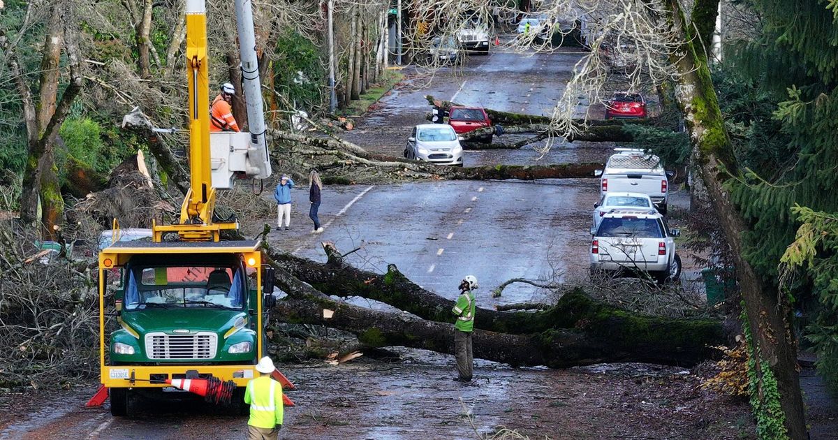
Hurricane-force winds are not only expected along a stretch of Florida's Gulf Coast in areas covered by hurricane alerts, but these high winds may also penetrate well inland into parts of northern Florida, southern and perhaps even Middle Georgia Thursday night. Downed trees and power outages could be widespread in these areas, and even some structural damage is possible.
Tropical storm-force winds will quickly spread up western Florida's coast to the panhandle Thursday into Thursday night. These tropical storm-force gusts could then push well inland into much of Georgia, extreme eastern Alabama, South Carolina and western North Carolina Thursday night into Friday. Downed trees and power outages are quite possible in these areas. This includes the Atlanta metro area.
Rainfall
Rainfall both ahead of Helene and associated with the storm could trigger catastrophic flooding in parts of the southern Appalachians.
That's because heavy rain is expected well ahead of Helene's arrival from parts of Georgia, including the Atlanta metro area, into the southern Appalachians through early Thursday. This, alone may trigger flash flooding.
Then, the bands of heavy rain from Helene will arrive later Thursday into early Friday, falling on saturated ground from the previous day's rain.
This double round of heavy rain, in addition to the hilly and mountainous terrain, is a prime setup for destructive, life-threatening rainfall flooding and landslides. A rare "high risk" flood outlook has been issued by NOAA's Weather Prediction Center from northeast Georgia into western North Carolina.
Total rainfall in parts of North Georgia into upstate South Carolina and western North Carolina could reach 18 inches. If that wasn't enough, the increasingly soggy ground in the Southeast may also make it easier for Helene's winds to topple trees.
Elsehwere, a broad area of at least 3 inches of rainfall is expected from Florida to the central Appalachians and westward into Kentucky, Tennessee and parts of the mid-Mississippi Valley. At least local flash flooding is possible in these areas.
Tornado Threat
Many landfalling hurricanes also produce a tornado threat to the right, or in this case east, of where the center tracks.
Parts of Florida, southeast Georgia and southern and eastern South Carolina have the greatest chance of a few tornadoes Thursday and Thursday night. A lower tornado threat may extend into eastern North Carolina and southern Virginia on Friday.
The impacts from Helene won't stop at the coast. Life-threatening flash flooding, damaging winds and some tornadoes will also spread well inland into parts of the Southeast.
(MORE: Map Tracker)
Where is it now: Helene became the fifth hurricane of the 2024 Atlantic hurricane season late Wednesday morning. It is centered just over 400 miles southwest of Tampa, Florida, and is tracking north. Maximum sustained winds are 85 mph.
The storm is slowly pulling away from Mexico's Yucatan Peninsula, but still drenching western Cuba. Wind gusts to 69 mph have been measured at Isla Mujeres, an island just northeast of Cancún, and parts of western Cuba have picked up over 7 inches of rain, so far.
Meanwhile, bands of heavy rain have developed well ahead of Helene over parts of the Southeast U.S., prompting occasional flash flood warnings as far north as southwest Virginia. Several roads were already flooded Wednesday afternoon in parts of Greene and Sevier Counties in eastern Tennessee.
Watches and warnings in effect: A hurricane warning is in effect from Florida's Big Bend and Nature Coast into southwest Georgia, including Tallahassee. Storm surge warnings extend from Mexico Beach southward to Flamingo, including Tampa Bay and Charlotte Harbor.
As shown in the map below, tropical storm warnings cover almost the entire rest of Florida and Georgia not covered by hurricane warnings, all of South Carolina and much of western North Carolina.
These alerts mean hurricane, tropical storm and storm surge conditions are expected in these areas as Helene moves in.
Interests in the warned areas should implement their hurricane plans and heed any advice from local emergency managers.
Here is the timeline:
- Thursday: Helene is expected to reach its peak intensity in the eastern Gulf and then make a landfall somewhere along the Gulf Coast of Florida as a large, intense hurricane Thursday night. That landfall is most likely to happen in Florida's Big Bend or eastern Panhandle region, but its impacts (surge, winds, rain) will happen far from the center, typical for larger storms.
- Friday: Helene will sweep quickly northward through the Southeast toward the southern Appalachians and Ohio Valley with strong, possibly damaging wind gusts, flooding rain and isolated tornadoes.
(Further beef up your forecast with our detailed, hour-by-hour breakdown for the next 8 days – only available on our Premium Pro experience.)
How strong could it become: Helene will likely become a major hurricane in the Gulf ahead of landfall.
That's because heat content is one favorable ingredient for intensification, and the map below Helene is headed for a reservoir of deep, warm water known as the Gulf of Mexico's loop current. In fact, Gulf of Mexico heat content is at record high levels for this time of year, according to University of Miami tropical scientist Brian McNoldy.
One other factor to consider is wind shear. Wind shear typically limits or weakens tropical storms and hurricanes by either tilting their circulation or blowing more thunderstorms away from its core.
Lower wind shear will allow Helene to fully take advantage of that deep, warm water. Some increase in shear may arrive near landfall, but by that time, it will likely be an intense, large hurricane.
(For even more granular weather data tracking in your area, view your 15-minute details forecast in our Premium Pro experience.)
U.S. Impacts
Storm Surge
The National Hurricane Center's storm surge forecast is shown in the embedded post below. As you can see, much of the Florida Gulf Coast is expected to see at least some storm surge flooding, including areas as far south as the Keys.
However, a potentially catastrophic storm surge is expected along and to the east of where Helene's center makes landfall in Florida's Big Bend, Apalachee Bay and Nature Coast. Some surge inundation of 10 to 20 feet above ground level is forecast in these areas. For Cedar Key, that would top a record storm surge set 128 years ago, and could be at least twice the surge inundation from Hurricane Idalia in August 2023 (6.84 feet).
Given Helene's anticipated large wind field, significant storm surge flooding is also expected in the Tampa-St. Pete-Sarasota metro areas that is expected to be several feet higher than what was experienced over a year ago with Hurricane Idalia.
If you live near the coast, know your evacuation zone and heed any orders from local emergency management.
Winds
As alluded to earlier, Helene will be both a large, intense and fast-moving hurricane in the Gulf and then will plow inland. That means its strong winds will cover a larger area and push farther inland than usual.
Hurricane-force winds are not only expected along a stretch of Florida's Gulf Coast in areas covered by hurricane alerts, but these high winds may also penetrate well inland into parts of northern Florida, southern and perhaps even Middle Georgia Thursday night. Downed trees and power outages could be widespread in these areas, and even some structural damage is possible.
Tropical storm-force winds will quickly spread up western Florida's coast to the panhandle Thursday into Thursday night. These tropical storm-force gusts could then push well inland into much of Georgia, extreme eastern Alabama, South Carolina and western North Carolina Thursday night into Friday. Downed trees and power outages are quite possible in these areas. This includes the Atlanta metro area.
Rainfall
Rainfall both ahead of Helene and associated with the storm could trigger catastrophic flooding in parts of the southern Appalachians.
That's because heavy rain is expected well ahead of Helene's arrival from parts of Georgia, including the Atlanta metro area, into the southern Appalachians through early Thursday. This, alone may trigger flash flooding.
Then, the bands of heavy rain from Helene will arrive later Thursday into early Friday, falling on saturated ground from the previous day's rain.
This double round of heavy rain, in addition to the hilly and mountainous terrain, is a prime setup for destructive, life-threatening rainfall flooding and landslides. A rare "high risk" flood outlook has been issued by NOAA's Weather Prediction Center from northeast Georgia into western North Carolina.
Total rainfall in parts of North Georgia into upstate South Carolina and western North Carolina could reach 18 inches. If that wasn't enough, the increasingly soggy ground in the Southeast may also make it easier for Helene's winds to topple trees.
Elsehwere, a broad area of at least 3 inches of rainfall is expected from Florida to the central Appalachians and westward into Kentucky, Tennessee and parts of the mid-Mississippi Valley. At least local flash flooding is possible in these areas.
Tornado Threat
Many landfalling hurricanes also produce a tornado threat to the right, or in this case east, of where the center tracks.
Parts of Florida, southeast Georgia and southern and eastern South Carolina have the greatest chance of a few tornadoes Thursday and Thursday night. A lower tornado threat may extend into eastern North Carolina and southern Virginia on Friday.
Comments( 0 )

0 0 0


0 0 2